Mastodon

We're looking for the trash fence...

Suggestions on Winlink Position Reports

Posted on Sat 14 January 2012 in Amateur Radio

This is for all you Maritime Mobiles who are probably not really active in HAM Radio, but are using Winlink for email and position reports. Here are few operating suggestions:

Sending Position Reports

image

  • When you send a position report, ALWAYS but your vessel name in beginning of the comment fields. No one probably knows what your callsign is, but we can look around and see your boat name.
  • While underway, send at least one position report. I usually do this once a day on long passages or at roughly the midway on shorter passages. Its fun to later connect all the dots!
  • Always send a position report when you reach your destination indicating you are anchored or moored safely

Check Who’s around you

Did you know you can ask Winlink for a list of other people who are nearby? It goes without saying that you need to have updated your position recently for this to work. But assuming you have done that send a mail to INQURY with the subject REQUEST and the message body WL2K_NEARBY. Send that off and next time you check your mail you will have a list of nearby folks. Notice I didn’t say vessels. Winlink is for any HAM to use, so you will see RVers, Backpackers as well. Here’s a sample. If you always put your vessel name in your position report comments this is lot nicer to read!

List of users nearby W7PEA
Postion: 21-09.69N  105-13.60W  posted at: 1/11/2012 6:16:00 AM
(NOTE: All dates in UTC, distance in nautical miles and bearings true
great circle.)
Winlink 2000 Nearby Mobile Users
(Only the latest report for each call within the past 10 days is listed.
CALL     Dist(nm @ DegT)        POSITION             REPORTED           COMMENT
W7PEA          0.0 @ 000   21-09.69N 105-13.60W  2012/01/11 06:16  Deep
Playa - Anchored at Chacala
KJ6LNI        26.1 @ 198   20-44.83N 105-22.13W  2012/01/08 15:15  Anchored
in La Cruz
KJ6NYJ        26.5 @ 197   20-44.40N 105-22.00W  2012/01/10 23:08
VE0NAV        55.0 @ 319   21-50.88N 105-52.72W  2012/01/13 00:59
Arrived Isla Isabella much warmer here than Mazatlan All Good
KQ6MY         55.0 @ 319   21-50.88N 105-52.76W  2012/01/13 22:36
Isla Isabella
KJ6NKS       113.8 @ 169   19-18.03N 104-50.19W  2012/01/09 01:04  Here in
Tenacatita with all of our local friends
KD7NPI       113.8 @ 169   19-18.02N 104-50.15W  2012/01/09 00:39

Let People Know Who you Are

One of the best things you can do is to put your vessel name in your position reports. The next thing you can do is update your entry on the HAM Lookup servers, login to www.QRZ.com and www.HAMQTH.com and at least update your description with your vessel name and a link to your web page. This way if someone looks up your callsign because they saw it on Winlink they can know your vessel name and send you an email via Winlink or contact you on VHF. Pretty handy!


Actisense NGW-1-ISO Firmware Upgraded fixes incorrect Position passed to Icom M504

Posted on Thu 08 December 2011 in Nav Station

I have been noticing a problem with the position displayed in my Icom M504 VHF. My current latitude is 24°09.200N. But the VHF was displaying 2°49.200. The GPS data is fed to my VHF and my SCS PTC-IIUSB modem from the NMEA 2000 network via the Actisense NGW-1-ISO (NMEA 200 to NMEA 0183) gateway.

I contacted Actisense support and they suggested I upgrade the firmware in my NGW-1-ISO. That involved a multi-day hunt for serial cables here in La Paz. In the end, I found them at Sterens which is on Forjadores across the street from the Plaza de La Paz (AKA the Soriana shopping center) with help from the gang at Club Cruceros de La Paz. BTW, Sterens is an electronics store with all kinds of cables, connectors, and electronics doo-dads. More like a Radio Shack than a Frye’s, but better than the Radio Shack’s here and cheaper too! I paid \$89 MXN for 2 6ft serial cables.

Once I had the serial cable in hand, I cut one end off the end I wouldn’t be connecting to the computer. I then used the continuity test on my multimeter to label all the wires so I knew which wire went to which pin on the DB9 connector I would be plugging into my computer. You need to label each wire to its proper DB9 RS232 cable pinout because later you’re going to need to connect Pin X with the Red wire on the NGW-1-ISO, etc. This is not hard at all. Your digital multimeter has a continuity test. You stick one of the probes into Pin 1 and test each wire, when it beeps you label that wire as #1 and so on.

With all the wires labeled, I was ready to connect the NGW-1-ISO’s wires to the Serial Cable as specified in the NGW-1-ISO manual for connection to a PC. Once that was done, I ran Actisenses’s upgrade utility, selected the COM port the serial cable was connected to and performed the upgrade. I offer all that detail in case one of you needs to do it too. There currently is no other way to upgrade the non-USB Actisense gateways.

After all that, I connect everything back up to my ICOM M504 and the position is now being displayed correctly. This is VERY important in case we ever need to use the DSC Distress call on our VHF which transmits an alert and our position. Without this fix the position would have been wrong!

Crisis averted. The world is now safe for eating delicious homemade cupcakes which Dawn made last night. Its good here. Its very good here!


NMEA Data Sharing Across Applications and Platforms

Posted on Fri 23 September 2011 in Coastal Explorer

Systems - Electronics Slug: nmea-data-sharing-across-applications-and-platforms Status: published

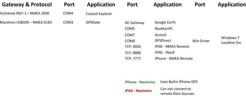
With a Maretron USB100 NMEA-0183 Gateway and an Actisense NGT-1 NMEA 2000 gateway I was struggling to get the NMEA data to all the applications on my PC, iPAD and iPhone. Many applications can not only connect to the an NMEA data source but also share the data on another TP Port or Virtual Com Port. Originally I was using a complicated stack of software all connected to each other to get data to some of the applications but couldn’t really use them all at once. More importantly which ever app I felt like using at the time might require starting up two applications!

Well in comes GPSGate Client (\$40) which lets you connect to a data source and then share it with many other applications.

You can see in the graphic below that I’ve dedicated the Actisense Gateway to Coastal Explorer. GPSGate is then connected to the Maretron Gateway and then it is used to serve up the data to 7 other applications some on Windows and some on my WiFi iPad and iPhone.

Also of note is that my preferred iOS navigation application Navionics works fine on the iPhone since it has a built-in GPS, but on the WiFi iPad there’s no way to get the NMEA data into the application. I’ve contacted Navionics about this and we’ll see if they add the functionality.

NMEA Data Sharing

This is greatly simplified from the way I was doing it before and I’m very excited to not only have all this finally working but to have it working simply! \$40 for GPSGate was worth every penny!


AIS is worth it !

Posted on Mon 11 July 2011 in Gear

This has been our first time out with AIS on the boat and I must say it is absolutely worth it. Being able to see exactly where that tug is headed and it’s speed is very useful. Even more useful is when you want to cutoff the shipping traffic separation lanes, you can “see” way up the sound and know whether or not a freighter or tug is coming around that next bend.

If you have been unsure about AIS… GET IT !


12V DC Ship’s Computer by Aleutia

Posted on Thu 17 March 2011 in Buying Guide

I just ordered the PC which will become the heart of our navigation systems--the Aleutia P1 Marine PC (@Aleutia).

I have probably spent 4 the equivalent of four full days mostly late at night looking into fanless PCs that either designed to be run on 12V DC power or happen to be powered as such but come with an AC-DC converter. PCs in that secondary category might work fine hooked directly up to the ship’s 12V power, but really should be run on a DC to DC regulator that essentially guarantees the PC is seeing 12V consistently or if it’s a 19V PC (lots of options out there for that) then it could handle that as well. I would look at the Carnetix Regulators if you decide to go that route.

I decided on the Aleutia because I felt it was the most hardware for the right price. I’m not saying it was the cheapest! However it is a very cable power sipping PC that can do the work I need. It also has the advantage of already being able to accept a wide input of DC power (6V-32V DC) which means I won’t need the regulator for the PC (I might still need one for a monitor TBD). Here’s a quick list of the specs of the unit I selected:


Processor Intel ATOM D510 1.66GHz (The lower power slower of the two choices) RAM 4GB (Upgraded from 2GB) System Cooling Fanless Power Input 6V – 12V DC Power Draw 19W * Let’s discuss this below Solid State Drive (SSD HD) I will supply OS I will supply Bulkhead Mountable YES Tested in Nigeria YES – No really… Wi-Fi No * (Optional) 64Bit Yes


I didn’t include a Solid State Drive  because their options for SSD HD were limited and I can slide in a better larger drive than their choices.

I didn’t buy Windows 7 64 bit from them because I have a better deal than theirs.

I didn’t include Wi-Fi because this PC is going to be mounted less than a foot from the wireless access point. I will cable it directly instead.

As for the power draw, the PC is designed to be very efficient, but if I go buy a crappy SSD which is a power hog then this will all be for naught. When I select my SSD I need to be very conscious of that! Aleutia’s options were for a 32GB or a 64GB Corsair Nova SSD which draw 0.5W (0.04A @ 12VDC) at idle and 2.0W (0.16A @ 12VDC) max. If I bought Corsairs most high performance SSD it would draw 0.2A at idle 0.5A Max. Not as much as other things on the boat, but I want this PC to stay on 24x7 so I need to watch every little bit I can. I’ll probably go with the Corsair Force F120 120GB SSD because it is larger, has better perf and the same power draw as the NOVA series which Aleutia has spec’d and tested. I might be able to find an even more miserly SSD but I’ve not looked yet.

The next step is making a decision about the Monitor…. but that is another post for another day.


Using Coastal Explorer to it fullest

Posted on Thu 10 March 2011 in Coastal Explorer

I like Coastal Explorer because it's UI is easy to use and has a similiar look and feel to Microsoft Office. I believe the Rosepoint Devs are a bunch of former Microsoft folks (me too) so that makes sense. Here are a couple of handy tips to use Coastal Explorer more effectively

SEARCH

The search functionality in Coastal Explorer actually has nothing to do with the charts (WTF!?! yep... I feel the same way). According to Brad the CE Guru, "the Search functionality searches gazetteers, databases of names and places, guide books, and a few other things". Try it.

Seach for La Paz. Did you get any hits for Mexico? Neither did I even after buying charts for Mexico from ChartWorld. To get the place names you need to download the Gazetteers for all the countries you wish to have. You can get the gazetteers on Rose Point's web site and then you copy them to C:Program Files (x86)Coastal ExplorerGazetteer (on non 64 bit Windows drop the "x86") and restart Coast Explorer. BINGO now CE works better. Still not sure why they don't search the chart files, but this works for geographixc features and place namses. I dont' think it will work for anything navigational though.

CHARTS

image

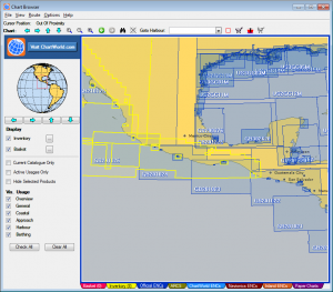
I mentioned I recently purchased and download a chart of Mexico. Actually, I tried this over the Holidays just for fun and was really dissatisfied. Chartworld's website is pretty bad and very confusing. I found it very difficult to figure out what detail a chart wold provide and even to find charts for the location I wanted. Well three months later I wanted to give this another shot because I was certain that despite the bad web site I could figure it out. Well, I did sort of, by NOT using the website!! Chartworld has a desktop application called Chart Browser that let's you look at different locations on the Earth and the charts available in those ares. From there you can add them to your cart. Calling it cart is a tad unfortunate. They should have called it a shopping list because what you do is save the cart to a file and then upload that chart to the afore mentioned bad website. Chart Browser also let's you add charts to your "inventory" which let's you track what charts you already have. The usability of Chart Browser is still not awesome, but its much better than the web site alone and I'm sure it's how I'll be building my shopping lists from now on.

One other hint about Chart Browser, as your using it to browse the world make sure on the bottom edge of the screen you're selecting the right set of charts to be looking at. For Coastal Explorer this is any of the Tabs with ENC in then name. Stick with those and you'll be fine.

Just some things I've figured out which I thought I'd share! I have lots more to learn about Coastal Explorer and you can bet I'll share it as I do!


Finally...a cool Android app...

Posted on Wed 02 February 2011 in Geek

Panbo has a pointer to an Android App that shows tidal currents... it looks pretty good.

Finally...a cool Android app....


RADAR Options Greatly Simplified

Posted on Wed 29 December 2010 in Gear

I think I should have be reincarnated as a search engine; I love to look things up. And in that vein I’ve ben doing all kinds of research on RADARs and PC Navigation Software packages and as a slight backup plan by looking into Chartplotters. That was a really open ended problem space and a tad frustrating to look at all that data and feature comparisons.

I was able to boil all that down pretty quickly since I’ve decided for sure to go the PC Software route with no chartplotter. Instead of a chartplotter I’ll use a Tablet PC and the Maretron DSM 250 instrument display in the cockpit.

When you look at RADARs they have two ways to connect:1) through a chartplotter and to a network or directly to a PC or 2) through a box that puts the RADAR data onto a network which the PC can plug into. This second mode is what I need, so that narrows it down to Koden’s RADARpc’s MDS-50R 18” radome and MDS-51R 24” radome and the Nobeltec IR2-4D 24” radome (seems their 2kW offering has been discontinued).

With Nobeltec you have the option of using Nobeltec Admiral or VNS navigation programs.

With the Koden RADARpc you have the option of using the following software packages:

Some general thoughts about these:

P-Sea is not a properly built or designed Windows 7 Application. The first thing they tell you to do before installing is to turn off some Windows 7 security features. I’m not willing to do that so I’m not going to be able to evaluate P-Sea.

iExpedition is apparently really cool, but I can’t find a reliable website that is clearly the development company that has contact information, support forums, all the things I’d expect for a quality software package. Maybe it exists and I can’t find it but without that I’m not even going to bother.

Now we’re down to RosePoint and Nobeltec. I have RosePoint and like it pretty well, they’re a local company which is nice. They’re also very responsive on their forums. I was very intrigued by the network and multi-PC capabilities of EuroNa'v’s SeaPro 3000, but it doesn’t support RADARChart overlay and that lead me to ask about Coastal Explorer’s plan for multiple PC scenarios which it turns out are the high priority for this year.

I don’t know much at all about Nobeltec, but I’m going to seek out a demo copy.

At any rate that was a long winded way of saying that I’ve narrowed down my RADAR to the Koden RADARpc MDS-51R, now I just need to look for the best price, possibly with a software package deal.


Thinking about data

Posted on Tue 06 July 2010 in Geek

I’ve been thinking about the blog, sailing reports, weather reports and all kinds of information I’d like to collect and share. Principally, I’ve been thinking about the data that will soon be running around my NMEA 2000 network. Some of the data will include course, speed, depth, air temperature, water temperature, humidity, barometer, etc. all of kinds of great info and all of it will have location as well. Has anyone out there taken the full output off their NMEA 2000 network and converted it to timelocation sorted KML entries as Custom Data? If I could get to that then I’d at least able to view the data in Google Maps, or easily convert it to a variety of formats.

I’ll have to ping Kurt at UNH and Nomadness about this.


Rose Point Navigation Coastal Explorer

Posted on Mon 10 May 2010 in Classes and Workshops

Last week I went to a talk on Rose Point Navigation Coastal Explorer (CE) which was hosted by Armchair Sailor here in Seattle, WA. The crowd was about 60 strong and there were a handful of folks in the under 50 crew.

The talk was lead by Jeff Hummel who does all these talks at the Boat Shows. He previously worked for Nobeltec and has been around the industry for awhile specifically with RADAR and software based chart plotters.

He basically went through all the core functionality in Coastal Explorer 2009 and then gave a good overview of the improvements in Coastal Explorer 2010 which is now in beta. Here’s a brief run down of some cool things Jeff demoed independent of version:

  • Active Captain Data viewable in CE2010 This basically supplies local knowledge that you can see in the live map view around you and then click to read information on anchorages, tricky entrances, anything really.
  • RADAR They’ve had this for a while a now. Basically they OEM Koden RADARs which with CE. There is so much press about HD and Broadband RADARs though they they appear a bit behind the times. For offshore cruisers I think they’d be fine.
  • See other features on the Coastal Explorer site.
  • The new UI in Coastal Explorer 2010 Beta is much improved.
  • Navigating the charts feels more like using standard web mapping software.
  • The menuing system which looks like the Office Ribbon shows you more of what’s available instead of digging through lists.

A solid good talk and if you have a chance to attend one of these I’d go for it.